

Arabel Valley

78°03′48″ E

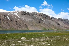
Arabel Valley is a high-mountain plateau and valley area in Issyk-Kul Region of Kyrgyzstan, south of Issyk-Kul Lake. Arabel lies within the inner high-altitude syrt landscapes of the Tien Shan, near Barskoon Gorge and the Kumtor mine area. The plateau is known for harsh mountain scenery, numerous small lakes, wetland areas, glacial landforms and an almost arctic feeling at an elevation of about 3,800 metres above sea level.[1][2]
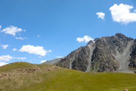
Arabel differs from the greener gorges of the northern Tien Shan. There is less forest here and more open space, stony plains, high-mountain meadows, lake basins and glacial streams. Because of this, the valley feels like a separate natural world within Issyk-Kul Region.
Corrections, route questions and additions can be left on the article's discussion page.
Geography
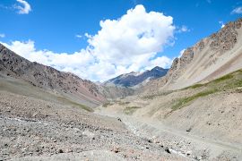
Arabel Valley is located in the southern part of Issyk-Kul Region, deep in the Terskey Ala-Too mountain system. In a broader geographical sense, it belongs to the high-mountain syrts: wide open plateaus and valleys situated between mountain ranges and lying far above ordinary inhabited valleys.[3]
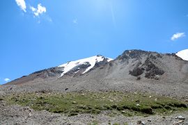
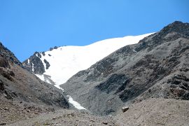
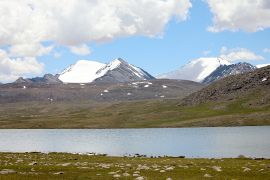
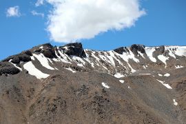
Elevations in the Arabel area are usually around 3,700-4,000 metres above sea level. Tourist and reference descriptions commonly place the plateau at about 3,800 metres.[1][2] In some parts of the syrts, the elevation exceeds 4,000 metres, with glaciers and higher peaks of the central Tien Shan nearby.
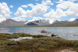
The landscape was shaped by ancient glaciers. After their retreat, flattened surfaces, moraine forms, numerous depressions and lake basins remained. This is why Arabel has so much water: lakes, streams, wetlands and the sources of mountain flows are fed by precipitation and the melting of snow and ice.[2]
Climate and nature
The climate of Arabel is severe even in summer. At this elevation the weather changes quickly: sunshine, cold wind, rain, fog and snow can all occur within a single day. Average annual temperatures are low and the warm season is short.[4]
Vegetation in the valley is poorer than in the lower gorges of Issyk-Kul Region. High-mountain grasses, mosses, lichens and low alpine vegetation predominate. Forests are almost absent, while open spaces, glacial streams, stony slopes and lakes are highly visible.
In clear weather, Arabel is especially expressive because of the contrast between green or brown high-mountain meadows, grey mountains, snow patches, glaciers and bright lakes. In autumn and at the beginning of the season, the valley can look almost deserted and very cold, which is why it is often compared with high-mountain tundra.[1]
Lakes and water system
One of the main features of Arabel is the large number of high-mountain lakes. They differ in size, depth and water colour. Some lakes are small and seasonal, while others are clearly visible on routes across the plateau. Their origin is connected with glacial relief: water collects in depressions left after ancient glaciation.[1]
Water in the valley comes from snow, glaciers, precipitation and numerous streams. Because of this, the terrain can be wet and marshy, especially near lakes and in low parts of the relief. For walks across the plateau, it is important to consider not only distance, but also ground conditions, weather and altitude.
Route and visiting
The most common route to Arabel goes from the southern shore of Issyk-Kul through Barskoon village and Barskoon Gorge. From Karakol, the trip to the Barskoon area usually takes about one and a half to two hours; from Bishkek, it takes about five to six hours to reach the southern shore of Issyk-Kul, after which the road continues toward the gorge and the plateau.
The road to Arabel is high-altitude and long. It passes through Barskoon Gorge, rises to mountain passes and then opens onto the syrts. A four-wheel-drive or well-prepared vehicle is recommended. Even when the road is passable for vehicles, weather, snow, washouts and road surface conditions can change travel conditions quickly.
Arabel is usually visited as a jeep tour or as a long day trip from the southern shore of Issyk-Kul. For an independent visit, it is worth checking the road condition, weather forecast, mobile coverage and possible restrictions connected with the nearby Kumtor industrial area and high-mountain sections.
Kumtor and economic significance
The Kumtor area, one of the largest gold deposits in Kyrgyzstan and Central Asia, is located near Arabel. For many years the mine was associated with the Canadian company Centerra Gold. In 2022, after agreements between the parties, 100% of the shares of the companies operating Kumtor were transferred to Kyrgyzaltyn OJSC.[5]
Because of the proximity to Kumtor, Arabel is sometimes discussed not only as a tourist area, but also as an environmental one. For travellers, this means that industrial roads, service vehicles and areas with restricted access may be encountered nearby. When planning a route, it is better to rely on current information from local guides and avoid areas not intended for tourists.
Interesting facts
- Arabel belongs to the high-mountain syrts: wide open plateaus that are rarely encountered at such an elevation in the tourist-accessible part of Kyrgyzstan.
- The plateau contains dozens of lakes and lake basins, many of them connected with ancient glaciation.
- Snow, fog and sudden cold weather are possible in the valley even in summer.
- A trip to Arabel is often combined with a visit to Barskoon Gorge and the Barskoon waterfalls.
- The area is interesting not only for travellers, but also for geographers, geologists and climate-change researchers, because glaciers and high-mountain lakes here are sensitive to climate shifts.[3]
Images of the valley
-
 High-mountain Arabel Valley
 -
 Lakes and open spaces of the plateau
 -
 Mountain landscape of Arabel
 -
 Road across the high-mountain valley
 -
 Lake basins
 -
 Syrt landscapes
 -
 Snow on the mountain summits
 -
 Arabel Plateau


Author's note
Arabel Valley is one of the most unusual places on the southern side of Issyk-Kul. It is not a classic green gorge, but an open high-mountain space with lakes, wind, glacial streams and very changeable weather. A trip here complements the route through Barskoon well: first the traveller sees the gorge, waterfalls and mountain road, and then reaches a nearly treeless plateau where the scale of the Tien Shan is felt especially strongly.
It is better to travel to Arabel with extra time, warm clothing and an understanding that an altitude of around 3,800 metres can be felt even during short walks. In good weather this place leaves a strong impression, but it requires caution and respect for the mountains.
Other articles about gorges in Kyrgyzstan
Sources
- ↑ 1.0 1.1 1.2 1.3 Arabel Valley. Too.kg.
- ↑ 2.0 2.1 2.2 Arabel. DWC.
- ↑ 3.0 3.1 Arabel Suu Syrt. Nomad's Land.
- ↑ Jeep tour: Arabel Plateau 4000 m. Visit Karakol.
- ↑ Current status of Kumtor Gold Company CJSC. Kumtor Gold Company.