

Sulaiman-Too

72°46′58″ E

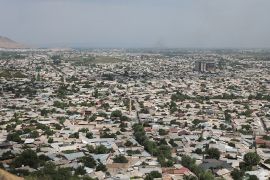
Sulaiman-Too is a sacred mountain in the city of Osh in southern Kyrgyzstan. It rises above the Fergana Valley and the historic city of Osh, which lies at the crossroads of important routes of the Silk Roads. In 2009, the property “Sulaiman-Too Sacred Mountain” was inscribed on the UNESCO World Heritage List and became the first World Heritage property in Kyrgyzstan.[1]
Sulaiman-Too is known as a pilgrimage site, an archaeological and cultural monument, a natural landmark of Osh and one of the main attractions of southern Kyrgyzstan. According to UNESCO, the mountain has been revered as sacred for at least one and a half millennia; its peaks and slopes contain ancient places of worship, caves, petroglyphs and structures associated with Islamic and pre-Islamic traditions.[1]
History and significance
Sulaiman-Too has long served as a place of pilgrimage. The mountain is connected with ideas about the sacred power of mountains, healing and blessing. According to UNESCO, 17 places of worship are recorded within the property, some of which are still in use, as well as 101 sites with petroglyphs depicting humans, animals and geometric forms.[1]
The veneration of Sulaiman-Too combines pre-Islamic and Islamic traditions. In local culture, the mountain is associated with the prophet Sulaiman, while particular caves, stones and passages have their own legends and ritual functions. These stories are important as part of intangible heritage, but they should be distinguished from archaeological and documented evidence.
The mountain and its surroundings include places of worship, pilgrims' paths, caves, viewpoints and reconstructed historical structures. UNESCO notes that Sulaiman-Too is considered one of the most complete examples of a sacred mountain in Central Asia, where a tradition of veneration has continued for many centuries.[1]
UNESCO World Heritage Site
Sulaiman-Too was inscribed on the World Heritage List as a cultural property under criteria (iii) and (vi).[1] Criterion (iii) relates to testimony to a cultural tradition, while criterion (vi) is connected with living religious and spiritual practices associated with the mountain.
The World Heritage property covers 112 ha, and its buffer zone covers 4,788 ha.[1] The preservation of Sulaiman-Too depends not only on the protection of individual caves, petroglyphs and cult places, but also on the protection of visual links, paths, the historic landscape and the urban setting around the mountain.
Geography and features
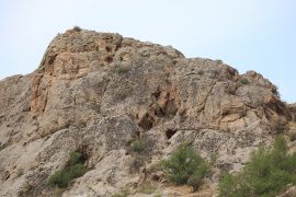
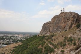
Sulaiman-Too is located in the center of Osh. The mountain stretches above the urban area and is visible from many parts of the city. It has five main peaks:
- Baara, also known as Solomon's Throne;
- Shor;
- Rushan;
- Eer;
- Kekilik, also known as Kattama.
The mountain rises about 150 m above the city. It is about 1,140 m long, about 560 m wide at the base, and its highest point reaches approximately 1,175 m above sea level. The coordinates of the UNESCO property are 40°31′52″ N, 72°46′58″ E.[1]
Caves, petroglyphs and museum
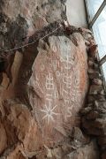
Sulaiman-Too contains caves, rock passages, petroglyphs and cult sites. These features make the mountain not only a natural attraction, but also an archaeological, religious and museum space.
Among the best-known caves are Chakka-Tamar, also called Tamchy-Tamar, and Tepeunkur. They are associated with local legends and pilgrimage practices. In some places visitors lean against stones, pass through narrow openings or pray, linking these actions with requests for health, well-being and longevity.
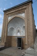
One of the caves houses the Sulaiman-Too museum complex. Its exhibitions present the history of Osh, the archaeology of the region, traditional culture and the religious significance of the mountain. Before visiting, it is better to check the current opening hours of the museum and the accessibility of particular areas, as rules may change.
Cult places and pilgrimage
Sulaiman-Too remains an active pilgrimage site. Cult places are located on different peaks and slopes, and footpaths connect them. In traditional beliefs, particular parts of the mountain are associated with healing barrenness, headaches, back pain and with the blessing of longevity.[1]
Today Sulaiman-Too is visited by both pilgrims and tourists. For some, the mountain has religious significance; for others, it is a historical monument, an open-air museum and one of the best viewpoints over Osh.
Photo gallery
- Photos of Sulaiman-Too
-

-

-
-

-
-
-
-


Routes and access
The main approaches to Sulaiman-Too are located within the urban part of Osh. One convenient access point is on Gapar Aitiev Street, near its intersection with Shota Rustaveli Street. From there, paths lead to the museum, viewpoints and trails to the peaks.
Sulaiman-Too is surrounded by dense residential, religious and administrative development. Irrigation channels run around the mountain on the southern and northern sides, while improved and natural paths cross the slopes. Comfortable footwear is recommended: some sections pass over rocks and steps, and open areas can be hot in summer.
How to get there
Sulaiman-Too is located inside Osh, so it can be reached by city transport, taxi or on foot from central districts. Bus and minibus routes near the mountain may change, so it is better to check current transport information locally or through local map services.
Useful landmarks include the Sulaiman-Too stop, the Osh State University area and Gapar Aitiev Street. For first-time visitors to Osh, the easiest option is usually to take a taxi to the museum entrance or to the nearest viewpoint trail.
Conclusion
Sulaiman-Too is not only a natural attraction, but also one of the key symbols of Osh and the cultural heritage of Kyrgyzstan. The mountain brings together the urban landscape, ancient cult practices, archaeological monuments, museum space and a living pilgrimage tradition. A visit to Sulaiman-Too offers views over Osh and helps explain the importance of sacred mountains in Central Asian culture.