Template:Lake/doc
Appearance
Issyk-Kul
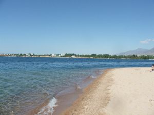
Summer at Issyk-Kul
Country:
Region:
Issyk-Kul region
Coordinates:
Latitude: 42°26′1″
Longitude: 77°15′46″
Longitude: 77°15′46″
Square:
6236 km²
Height:
1603 meters
above sea level
above sea level
Depth:
Maximum - 702 m.
Average - 210 meters.
Average - 210 meters.
Type of water:
salty (5,9 %)
Water temperature:
Average (summer): 22°С
Average (winter): 3°С
Average (winter): 3°С
Rating:
This Template can be used at articles about lakes
{{Lake
|lake name =
|image =
|description =
|country =
|region =
|coords = Latitude: <br>Longitude:
|square =
|height =
|depth  =
|water type =
|water temp =
|rating =
|map =
- After equal sign fill all known information about a lake just like it is shown below:
{{Lake
|lake name = Issyk-Kul
|image = ik.jpg
|description= Summer at Issyk-Kul
|country = Kyrgyzstan
|region = Issyk-Kul region
|coords = Latitude: 42°26′1″<br>Longitude: 77°15′46″
|square = 6236 km²
|height = 1603 meters<br>above sea level
|depth  = Maximum - 702 m.<br>Average - 210 meters.
|water type = salty (5,9 %)
|water temp = Average (summer): 22°С<br>Average (winter): 3°С
|rating = 5
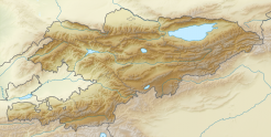
|map = {{Location map | Kyrgyzstan | AlternativeMap = Relief Map of Kyrgyzstan.png | width = 246 | float = center | caption = Issyk-Kul on the map | alt = Map of Kygzyzstan |label = Issyk-Kul | position = bottom | lat_deg = 42.4336 | lon_deg = 77.2627}}
}}


