Template:Gorge: Difference between revisions
Appearance
mNo edit summary Tag: 2017 source edit |
No edit summary Tag: 2017 source edit |
||
| Line 1: | Line 1: | ||
<includeonly> | <includeonly>{{Infobox | ||
{| | | title = {{{name|}}} | ||
| | | image = {{{image|}}} | ||
| | | description = {{{description|}}} | ||
| header color = #fde2b8 | |||
| parameters = | |||
{{#if:{{{general information|}}} | <div class="infobox-section">General Information</div> }} | |||
{{#if:{{{country|}}} | <div class="infobox-row"> | |||
<div class="infobox-label">Country:</div> | |||
<div class="infobox-value">{{{{{country}}}}} [[{{{country}}}]]</div> | |||
</div> }} | |||
{{#if:{{{region|}}} | <div class="infobox-row"> | |||
<div class="infobox-label">Region:</div> | |||
<div class="infobox-value">{{{region}}}</div> | |||
</div> }} | |||
{{#if:{{{mountain range|}}} | <div class="infobox-row"> | |||
<div class="infobox-label">Mountain range:</div> | |||
<div class="infobox-value">{{{mountain range}}}</div> | |||
</div> }} | |||
|- class=" | {{#if:{{{coords|}}} | <div class="infobox-row"> | ||
|| | <div class="infobox-label">Coordinates:</div> | ||
<div class="infobox-value">{{{coords}}}</div> | |||
</div> }} | |||
{{#if:{{{length|}}} | <div class="infobox-row"> | |||
<div class="infobox-label">Length:</div> | |||
<div class="infobox-value">{{{length}}}</div> | |||
</div> }} | |||
{{#if:{{{waterfall|}}} | <div class="infobox-row"> | |||
<div class="infobox-label">Waterfall:</div> | |||
<div class="infobox-value">{{{waterfall}}}</div> | |||
</div> }} | |||
{{#if:{{{rating|}}} | <div class="infobox-row"> | |||
<div class="infobox-label">Rating:</div> | |||
<div class="infobox-value">{{Rating|points={{{rating}}}}}</div> | |||
</div> }} | |||
{{#if:{{{map|}}} | | |||
<div class="infobox-map">{{{map}}}</div> | |||
}} | |||
{{#if:{{{portal|}}} | | |||
<div class="infobox-section" style="background:#fde2b8;">Thematic Portals</div> | |||
<div class="infobox-portal">{{{portal}}}</div> | |||
}} | |||
}}</includeonly><noinclude> | |||
{{documentation}} | |||
__NOINDEX__ | |||
[[Category:Templates]] | |||
[[wj-en:Template:Gorge]] | |||
{{ | |||
[[wj- | |||
[[wj-es:Plantilla:Desfiladero]] | [[wj-es:Plantilla:Desfiladero]] | ||
[[wj-fr:Modèle:Gorge]]</noinclude> | [[wj-fr:Modèle:Gorge]]</noinclude> | ||
Revision as of 17:16, 4 February 2025
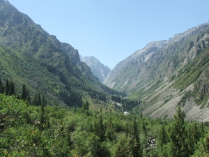
Ala-Archa Gorge
Ala-Archa Gorge
Country:
Region:
Chui region
Mountain range:
Kyrgyz range
Coordinates:
Latitude: 42°38′50″
Longitude: 74°29′32″
Longitude: 74°29′32″
Length:
≈ 20 km.
Waterfall:
Ak-Sai Waterfall
Rating:
Thematic Portals
This template is used in articles about gorges. Here is an example of how to fill in the template:
{{Gorge
|name =
|image =
|description =
|country =
|region =
|mountain range =
|coords =
|length =
|waterfall =
|rating =
|map =
|portal =
}}
- After the equals sign, fill in the appropriate information about the gorge (as shown in the example below). If some information is missing, leave the line empty.
{{Gorge
|name = Ala-Archa Gorge
|image = Ala-Archa.jpg
|description = Ala-Archa Gorge
|country = Kyrgyzstan
|region = Chui region
|mountain range = Kyrgyz range
|coords = Latitude: 42°38′50″<br>Longitude: 74°29′32″
|length = ≈ 20 km.
|waterfall = Ak-Sai Waterfall
|rating = 5
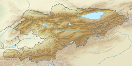
|map = {{Location map | Kyrgyzstan | AlternativeMap = Relief Map of Kyrgyzstan.png | width = 270 | float = center | caption = Ala-Archa Gorge at Kyrgyzstan map| alt = Map of Kygzyzstan |label = Ala-Archa | position = bottom | lat_deg = 42.5645 | lon_deg = 74.4824}}
|portal = [[Portal:Kyrgyzstan|Kyrgyzstan]] • [[Portal:Sights|Sights]]
}}
- To insert an image into the template, upload the file to our server and provide the filename in the "|image=" line. If you don’t want the image to be displayed, leave the line empty or use "|image = no_image.jpg".
- To add a map with the location marker for the gorge, use the specific location map template by including it in the "|map=" line. Example:
|map = {{Location map | Kyrgyzstan | AlternativeMap = Relief Map of Kyrgyzstan.png | width = 270 | float = center | caption = Ala-Archa Gorge at Kyrgyzstan map| alt = Map of Kygzyzstan |label = Ala-Archa | position = bottom | lat_deg = 42.5645 | lon_deg = 74.4824}}
If you need to add a custom map, please contact a Wikijournal administrator to create the appropriate template. If you have any questions, feel free to reach out to the administrator.
Template Data
| Template Data | |||||||||||||||||||||||||||||||||||||||||||||||||||||||||||||||||
|---|---|---|---|---|---|---|---|---|---|---|---|---|---|---|---|---|---|---|---|---|---|---|---|---|---|---|---|---|---|---|---|---|---|---|---|---|---|---|---|---|---|---|---|---|---|---|---|---|---|---|---|---|---|---|---|---|---|---|---|---|---|---|---|---|---|
|
This template is used to create articles about gorges
| |||||||||||||||||||||||||||||||||||||||||||||||||||||||||||||||||


