Template:Gorge/doc: Difference between revisions
Appearance
No edit summary Tag: 2017 source edit |
m Text replacement - "If you need to add a custom map, please contact a Wikijournal administrator to create the appropriate template. Don’t forget to use the "Preview" button to see how the page will appear. If you have any questions, feel free to reach out to the administrator." to "If you need to add a custom map, please contact a Wikijournal administrator to create the appropriate template. If you have any questions, feel free to reach out to [[User_talk:Admin|the adminis... |
||
| (4 intermediate revisions by 2 users not shown) | |||
| Line 1: | Line 1: | ||
{{Gorge | {{Gorge | ||
|name = Ala-Archa | |name = Ala-Archa Gorge | ||
|image = Ala-Archa.jpg | |image = Ala-Archa.jpg | ||
|description = Ala-Archa | |description = Ala-Archa Gorge | ||
|country = Kyrgyzstan | |country = Kyrgyzstan | ||
|region = Chui region | |region = Chui region | ||
| Line 8: | Line 8: | ||
|coords = Latitude: 42°38′50″<br>Longitude: 74°29′32″ | |coords = Latitude: 42°38′50″<br>Longitude: 74°29′32″ | ||
|length = ≈ 20 km. | |length = ≈ 20 km. | ||
|waterfall = Ak-Sai | |waterfall = Ak-Sai Waterfall | ||
|rating = 5 | |rating = 5 | ||
|map = {{Location map | Kyrgyzstan | AlternativeMap = Relief Map of Kyrgyzstan.png | width = | |map = {{Location map | Kyrgyzstan | AlternativeMap = Relief Map of Kyrgyzstan.png | width = 270 | float = center | caption = Ala-Archa Gorge at Kyrgyzstan map| alt = Map of Kygzyzstan |label = Ala-Archa | position = bottom | lat_deg = 42.5645 | lon_deg = 74.4824}} | ||
|portal = [[Portal:Kyrgyzstan|Kyrgyzstan]] • [[Portal:Sights|Sights]] | |portal = [[Portal:Kyrgyzstan|Kyrgyzstan]] • [[Portal:Sights|Sights]] | ||
}} | }} | ||
| Line 36: | Line 36: | ||
<pre> | <pre> | ||
{{Gorge | {{Gorge | ||
|name = Ala-Archa | |name = Ala-Archa Gorge | ||
|image = Ala-Archa.jpg | |image = Ala-Archa.jpg | ||
|description = Ala-Archa | |description = Ala-Archa Gorge | ||
|country = Kyrgyzstan | |country = Kyrgyzstan | ||
|region = Chui region | |region = Chui region | ||
| Line 44: | Line 44: | ||
|coords = Latitude: 42°38′50″<br>Longitude: 74°29′32″ | |coords = Latitude: 42°38′50″<br>Longitude: 74°29′32″ | ||
|length = ≈ 20 km. | |length = ≈ 20 km. | ||
|waterfall = Ak-Sai | |waterfall = Ak-Sai Waterfall | ||
|rating = 5 | |rating = 5 | ||
|map = {{Location map | Kyrgyzstan | AlternativeMap = Relief Map of Kyrgyzstan.png | width = | |map = {{Location map | Kyrgyzstan | AlternativeMap = Relief Map of Kyrgyzstan.png | width = 270 | float = center | caption = Ala-Archa Gorge at Kyrgyzstan map| alt = Map of Kygzyzstan |label = Ala-Archa | position = bottom | lat_deg = 42.5645 | lon_deg = 74.4824}} | ||
|portal = [[Portal:Kyrgyzstan|Kyrgyzstan]] • [[Portal:Sights|Sights]] | |portal = [[Portal:Kyrgyzstan|Kyrgyzstan]] • [[Portal:Sights|Sights]] | ||
}} | }} | ||
| Line 56: | Line 56: | ||
<pre> | <pre> | ||
|map = {{Location map | Kyrgyzstan | AlternativeMap = Relief Map of Kyrgyzstan.png | width = | |map = {{Location map | Kyrgyzstan | AlternativeMap = Relief Map of Kyrgyzstan.png | width = 270 | float = center | caption = Ala-Archa Gorge at Kyrgyzstan map| alt = Map of Kygzyzstan |label = Ala-Archa | position = bottom | lat_deg = 42.5645 | lon_deg = 74.4824}} | ||
</pre> | </pre> | ||
If you need to add a custom map, please contact a Wikijournal administrator to create the appropriate template | If you need to add a custom map, please contact a Wikijournal administrator to create the appropriate template. If you have any questions, feel free to reach out to [[User_talk:Admin|the administrator]]. | ||
== Template Data == | == Template Data == | ||
| Line 80: | Line 80: | ||
"description": { | "description": { | ||
"description": "A brief description of the gorge", | "description": "A brief description of the gorge", | ||
"example": "Panorama of Ala-Archa | "example": "Panorama of Ala-Archa Gorge" | ||
}, | }, | ||
"country": { | "country": { | ||
| Line 99: | Line 99: | ||
</templatedata> | </templatedata> | ||
|} | |} | ||
__NOINDEX__ | __NOINDEX__ | ||
<noinclude>[[Category:Template instructions]]</noinclude> | <noinclude>[[Category:Template instructions]]</noinclude> | ||
Latest revision as of 12:26, 22 February 2025
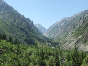
Ala-Archa Gorge
Ala-Archa Gorge
Country:
Region:
Chui region
Mountain range:
Kyrgyz range
Coordinates:
Latitude: 42°38′50″
Longitude: 74°29′32″
Longitude: 74°29′32″
Length:
≈ 20 km.
Waterfall:
Rating:
Thematic Portals
This template is used in articles about gorges. Here is an example of how to fill in the template:
{{Gorge
|name =
|image =
|description =
|country =
|region =
|mountain range =
|coords =
|length =
|waterfall =
|rating =
|map =
|portal =
}}
- After the equals sign, fill in the appropriate information about the gorge (as shown in the example below). If some information is missing, leave the line empty.
{{Gorge
|name = Ala-Archa Gorge
|image = Ala-Archa.jpg
|description = Ala-Archa Gorge
|country = Kyrgyzstan
|region = Chui region
|mountain range = Kyrgyz range
|coords = Latitude: 42°38′50″<br>Longitude: 74°29′32″
|length = ≈ 20 km.
|waterfall = Ak-Sai Waterfall
|rating = 5
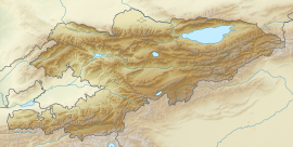
|map = {{Location map | Kyrgyzstan | AlternativeMap = Relief Map of Kyrgyzstan.png | width = 270 | float = center | caption = Ala-Archa Gorge at Kyrgyzstan map| alt = Map of Kygzyzstan |label = Ala-Archa | position = bottom | lat_deg = 42.5645 | lon_deg = 74.4824}}
|portal = [[Portal:Kyrgyzstan|Kyrgyzstan]] • [[Portal:Sights|Sights]]
}}
- To insert an image into the template, upload the file to our server and provide the filename in the "|image=" line. If you don’t want the image to be displayed, leave the line empty or use "|image = no_image.jpg".
- To add a map with the location marker for the gorge, use the specific location map template by including it in the "|map=" line. Example:
|map = {{Location map | Kyrgyzstan | AlternativeMap = Relief Map of Kyrgyzstan.png | width = 270 | float = center | caption = Ala-Archa Gorge at Kyrgyzstan map| alt = Map of Kygzyzstan |label = Ala-Archa | position = bottom | lat_deg = 42.5645 | lon_deg = 74.4824}}
If you need to add a custom map, please contact a Wikijournal administrator to create the appropriate template. If you have any questions, feel free to reach out to the administrator.
Template Data
| Template Data | |||||||||||||||||||||||||||||||||||||||||||||||||||||||||||||||||
|---|---|---|---|---|---|---|---|---|---|---|---|---|---|---|---|---|---|---|---|---|---|---|---|---|---|---|---|---|---|---|---|---|---|---|---|---|---|---|---|---|---|---|---|---|---|---|---|---|---|---|---|---|---|---|---|---|---|---|---|---|---|---|---|---|---|
|
This template is used to create articles about gorges
| |||||||||||||||||||||||||||||||||||||||||||||||||||||||||||||||||


