Template:Waterfall/doc: Difference between revisions
Appearance
Tag: 2017 source edit |
m Text replacement - "Ak-Sai waterfall" to "Ak-Sai Waterfall" |
||
| (One intermediate revision by the same user not shown) | |||
| Line 1: | Line 1: | ||
{{Waterfall | {{Waterfall | ||
|waterfall name = Ak-Sai | |waterfall name = Ak-Sai Waterfall | ||
|image = Ala-Archa_14.jpg | |image = Ala-Archa_14.jpg | ||
|description = Ala-Aracha waterfall | |description = Ala-Aracha waterfall | ||
| Line 6: | Line 6: | ||
|region = Chui region | |region = Chui region | ||
|mountain range = Kyrgyz range | |mountain range = Kyrgyz range | ||
|ravine = [[Ala-Archa | |ravine = [[Ala-Archa Gorge|Ala-Archa]] | ||
|river = Ak-Sai river | |river = Ak-Sai river | ||
|coordinates = Latitude: 42°32′48″<br>Longitude: 74°31′3″ | |coordinates = Latitude: 42°32′48″<br>Longitude: 74°31′3″ | ||
| Line 15: | Line 15: | ||
|width = 246 | |width = 246 | ||
|float = center | |float = center | ||
|caption = Ak-Sai | |caption = Ak-Sai Waterfall on the map of Kyrgyzstan | ||
|alt = Map of Kygzyzstan | |alt = Map of Kygzyzstan | ||
|label = Ak-Sai | |label = Ak-Sai Waterfall | ||
|position = bottom | |position = bottom | ||
|lat_deg = 42.5645 | |lat_deg = 42.5645 | ||
| Line 41: | Line 41: | ||
}} | }} | ||
</pre> | </pre> | ||
Below is an example of how to use the template for the '''Ak-Sai | Below is an example of how to use the template for the '''Ak-Sai Waterfall''' in Kyrgyzstan: | ||
<pre> | <pre> | ||
{{Waterfall | {{Waterfall | ||
|waterfall name = Ak-Sai | |waterfall name = Ak-Sai Waterfall | ||
|image = Ala-Archa_14.jpg | |image = Ala-Archa_14.jpg | ||
|description = Ala-Aracha waterfall | |description = Ala-Aracha waterfall | ||
| Line 50: | Line 50: | ||
|region = Chui region | |region = Chui region | ||
|mountain range = Kyrgyz range | |mountain range = Kyrgyz range | ||
|ravine = [[Ala-Archa | |ravine = [[Ala-Archa Gorge|Ala-Archa]] | ||
|river = Ak-Sai river | |river = Ak-Sai river | ||
|coordinates = Latitude: 42°32′48″<br>Longitude: 74°31′3″ | |coordinates = Latitude: 42°32′48″<br>Longitude: 74°31′3″ | ||
| Line 59: | Line 59: | ||
|width = 246 | |width = 246 | ||
|float = center | |float = center | ||
|caption = Ak-Sai | |caption = Ak-Sai Waterfall on the map of Kyrgyzstan | ||
|alt = Map of Kygzyzstan | |alt = Map of Kygzyzstan | ||
|label = Ak-Sai | |label = Ak-Sai Waterfall | ||
|position = bottom | |position = bottom | ||
|lat_deg = 42.5645 | |lat_deg = 42.5645 | ||
Latest revision as of 01:03, 20 February 2025
Ak-Sai Waterfall
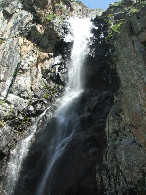
Ala-Aracha waterfall
Country:
Region:
Chui region
Mountain range:
Kyrgyz range
Ravine:
Coordinates:
Latitude: 42°32′48″
Longitude: 74°31′3″
Longitude: 74°31′3″
River:
Ak-Sai river
Waterfall height:
≈ 30 meters
Waterfall width:
≈ 5 meters
How to use Template
The {{Waterfall}} template is designed for articles about waterfalls. It allows users to structure and present information in a standardized format.
{{Waterfall
|waterfall name =
|image =
|description =
|country =
|region =
|mountain range =
|ravine =
|river =
|coordinates =
|waterfall height = ≈
|waterfall width = ≈
|map =
}}
Below is an example of how to use the template for the Ak-Sai Waterfall in Kyrgyzstan:
{{Waterfall
|waterfall name = Ak-Sai Waterfall
|image = Ala-Archa_14.jpg
|description = Ala-Aracha waterfall
|country = Kyrgyzstan
|region = Chui region
|mountain range = Kyrgyz range
|ravine = [[Ala-Archa Gorge|Ala-Archa]]
|river = Ak-Sai river
|coordinates = Latitude: 42°32′48″<br>Longitude: 74°31′3″
|waterfall height = ≈ 30 meters
|waterfall width = ≈ 5 meters
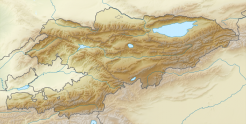
|map = {{Location map| Kyrgyzstan
 |AlternativeMap = Relief Map of Kyrgyzstan.png
 |width = 246
 |float = center
 |caption = Ak-Sai Waterfall on the map of Kyrgyzstan
 |alt = Map of Kygzyzstan
 |label = Ak-Sai Waterfall
 |position = bottom
 |lat_deg = 42.5645
 |lon_deg = 74.4824
 |mark = Blue_pog.png}}
}}
Notes
- The map parameter uses the
{{Location map}}template to display the waterfall's location on a map. Ensure that latitude (lat_deg) and longitude (lon_deg) values are correctly entered. - If an image is available, provide its filename in the
imageparameter without the "File:" or "Image:" prefix. - The
ravineandriverparameters can include internal wiki links to relevant articles. - Heights and widths should be approximate if exact measurements are unavailable.
By following these instructions, you can effectively document waterfalls using the standardized {{Waterfall}} template.


