

Alamedin Waterfall

Longitude: 74°39'16"

Alamedin Waterfall is a 10-meter-high waterfall located in the Alamedin Gorge in Kyrgyzstan, Chuy Region, approximately 35 km south of the capital, Bishkek.
Waterfall Characteristics
- The height of the waterfall is approximately 10 meters, with a width of about 2 meters.
- Until the end of April, the waterfall is usually frozen, and even in May, some ice blocks remain.
- The highest water flow occurs in summer due to intense ice melting on the mountain peaks. As a result, access to the waterfall can become significantly more difficult.
- The waterfall is located at an altitude of 2,120 meters above sea level.
Excursion Route
Alamedin Gorge is located about 35 kilometers from the center of Bishkek. It takes approximately one hour to drive from the outskirts of the city deep into the gorge to a parking area.
From there, visitors must walk an additional 5 kilometers along the scenic gorge to reach the waterfall. The elevation gain is minor, around 350 meters, making the hike accessible to anyone with minimal physical preparation.
The entire journey from the parking area to the waterfall takes about two hours. Along the way, hikers must cross the river three times: at the beginning via a bridge, before the turn to the waterfall, and right before the waterfall itself. Notably, the river is easiest to cross on stones in early to mid-May, when the water flow is not too strong. In summer, crossing becomes more challenging and dangerous, so caution is advised when crossing the river!
Waterfall Photos
- Фотографии Аламединского водопада
-
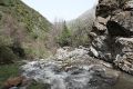 The river at the base of the waterfall
 -
 On the way to the waterfall
 -
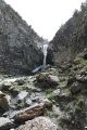 Alamedin Waterfall
 -
 Near the waterfall
 -
 Hanging ice blocks at Alamedin Waterfall
 -
 Waterfall stream in May


